OTG Launches New Interactive Map of Statewide Projects
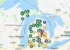
After nearly a week and a half of staring at my computer screen inputting data on OTG projects, I’m elated to say that the interactive map has officially launched! There were a couple of factors that lead to making this, but I think the most important was visualization. For me, I can read all of the blogs and look at every spreadsheet of projects that have been done, but the magnitude of what this program accomplishes doesn’t hit me until you lay it out on a map. Hopefully you’ll find it as interesting and gratifying as I do, because these projects certainly aren’t possible without our volunteers like you.
Here’s a couple things you can do with this map, and why it’s so handy:
- Project Labels
- Each project type has a different label, which makes it easier for you to see the different kinds of work being done at OTG projects around the state
- Project Data
- When you click on the project icon, it gives you the date that the project was done, who was involved, and the benefits that this project has to the surrounding wildlife populations
- It’s made for you
- Whether you’re an avid hunter, bird watcher, or other recreational user of state land, you can pick areas that we have worked at to better your chances of seeing your target wildlife species
- It’s up to date
- Each project will be added within a week after completion, so you’re always up-to-date on what we are accomplishing and how it benefits you
- It’s easier to get involved
- Now that there’s a visual representation of our projects, it’s easier than ever to identify the projects that we do near you, and get involved in one!
- Keep in mind
- There are many sites on the map where multiple projects have been done at the same state game area or forest. For example, we have done many projects at Grayling State Forest, Rose Lake State Game Area, Pigeon River Country State Forest, Gratiot-Saginaw State Game Area, etc. Zoom in really well to get the full impact of the work done!
To view the interactive map and learn all about our projects, click HERE. Additionally, it’ll be added to our website to the “On The Ground” page within the next couple of days. I’m very excited to provide you all with this tool and I hope that it encourages you to get involved on your local, public landscape.
As always, if you have any questions or comments about things that you would like to see the OTG program doing, or tools that would help you understand what we do, please don’t hesitate to reach out to me, Hunter Salisbury, at hsalisbury@mucc.org or 517-346-6456.