
In the Field: Conducting a Browse Survey
When you are looking to “manage” deer, it is very helpful to collect information that clues you into understanding deer numbers in your area and their impact on their habitat. Trail cameras can help estimate numbers of deer, and browse impact studies can help determine the impact they are having on their food source. If deer are overeating their food source, even without knowing “how many” deer there are, you should know that more does need to be harvested for the sake of the health of the herd. The deer browse impact survey is a great tool that gets out into the woods and helps you evaluate the level of impact deer are having. Below we cover some of the basics, however, there are links to articles with more details at the end of this blog.
In an ideal situation, you would plan to run the survey on around 500 acres of forest after snowmelt, but before green-up. But… who has 500 acres of contiguous forest? Chances are if you live in Southern Michigan, you don’t. If you live in Northern Michigan, you may, but chances are you don’t own all of it. For the sake of conversation, we will use 500 acres to describe the process, but feel free to tweak the process for your situation. For example, on my 12 acres (long and skinny), I simply ran two transects along the long borders of my land.
 If you have 500 acres, you would want to have 5 lines (transects) each 1,000 feet apart and 1 mile long. (If you were so lucky to have 1,000 acres, you would have two sets of 5 transects.) Along each mile-long transect, you want to stop every 100 feet (so that you have about 52 plots/line) and evaluate the browse impact within a 4 foot radius at each plot.
Suggested Equipment: Briar proof clothing, clipboard and pencil, data form (see below), compass (traditional, not your smartphone) and a walking stick with 4 feet marked on it
- Picking transect locations: Ideally, the transects should cover multiple cover types and be as straight as possible. Using an aerial map to plan your transects is recommended. You will want to avoid swamps, ponds, etc. Work with your neighbors if possible.
- Team up with crews of at least 2 people.
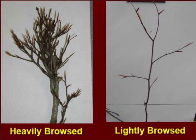
- Once you have your equipment and your team, you want to plan a day after the snow has melted, but before the leaves have popped out. At the beginning of one of your lines, make your first plot evaluation. Look at the plants within a 4 foot radius and determine the browse impact of the plants between 6 inches off the ground and 6 feet off the ground (the height deer eat at). Document how heavily the stems are browsed on your data form (link below). Once you have documented your observations, count about 30 paces, or 100 feet. Then evaluate the next plot.
- As you are going along your transect, keep your eyes open for pellet piles. Tally how many you see. Once you have collected all the data, there is an equation on the form that will allow you to estimate the deer density on the property based on the pellet numbers you have.

To view a seminar on Deer Browse Impact Surveys, select the links below.
Seminar Recordings: Part 1 — Part 2 — Part 3
Presentations from the seminar
To learn more about the Deer Browse Survey, check out the article below.
QDMA Article “Over the Limit” about conducting a deer browse study.